|
|
New York - Niagara Falls
 Niagara Fall, New York (575 alt., 55,593 pop.), stands in the corner formed by the river at the falls; and Niagara Falls, Ontario, stretches northward from the brink of the Horseshoe Falls. The world-wide reputation of the falls as a natural wonder attracts more than 1,500,000 visitors annuallyparticularly honeymoonerswho promenade along Falls Street and through the parks, crowd the many tourist quarters, and purchase countless souvenirs and camera films. The State has carefully preserved the beauty of the area above the falls; and, in order to preserve the cataract as a spectacle, a British-American treaty limits diversion of water to 20,000 cubic feet a second on the American and 36,000 on the Canadian side. Niagara Fall, New York (575 alt., 55,593 pop.), stands in the corner formed by the river at the falls; and Niagara Falls, Ontario, stretches northward from the brink of the Horseshoe Falls. The world-wide reputation of the falls as a natural wonder attracts more than 1,500,000 visitors annuallyparticularly honeymoonerswho promenade along Falls Street and through the parks, crowd the many tourist quarters, and purchase countless souvenirs and camera films. The State has carefully preserved the beauty of the area above the falls; and, in order to preserve the cataract as a spectacle, a British-American treaty limits diversion of water to 20,000 cubic feet a second on the American and 36,000 on the Canadian side. The wide lawns of Prospect Park extend to the very edge of the roaring waters. Crowding the park and reaching northward along the gorge to Ontario Avenue is the business and shopping district, a collection of threeand four-story structures dwarfed by the 17-story United Office Building. The main industrial district borders the river above the falls, and from the smokestacks along Buffalo Avenue constantly rise the fumes of industry.
The large central part of the city is residential, the more exclusive district being the De Veaux area to the north, just east of Whirlpool State Park.
Control of this region was of strategic value in the Colonial period because of the seven-mile portage around Niagara Fallsthe only break in the all-water journey between the St.Lawrence and the upper reaches of the Great Lakes. The first published view of Niagara Falls, reproduced in a volume in 1697, was a sketch made by Father Louis Hennepin, who visited the falls on December 6, 1678. In 1745 and 1750 the French built two forts near the falls to supplement Fort Niagara at the mouth of the river and to guard the upper end of the portage. Before the approach of the British in 1759, Chabert Joncaire, French master of the portage, burned the forts and retreated across the river.
Under British occupation, John Stedman received a grant of land along the river from the Indians and became master of the portage. Fort Schlosser, more substantial than its predecessors, was erected by Captain Joseph Schlosser, a German officer in the British army. An old stone chimney, the only part of the French forts not destroyed by Joncaire, was built into the mess hall of Fort Schlosser and now stands, reconstructed, on the grounds of the Carborundum Company.
Augustus Porter visited the place in 1795, returned in 1805 or 1806, purchased the land immediately surrounding the falls, moved his family there, built a gristmill, and succeeded Stedman as master of the portage. Visioning'a manufacturing center that would rival the English city, Porter named the settlement Manchester. The fighting that took place on the Niagara Frontier throughout the War of 1812 culminated in the burning of Manchester and Fort Schlosser by the British in 1813. Only a few houses escaped the flames.
When Porter realized that the Erie Canal had destroyed business on the portage, he urged capitalists to develop Niagara power. As a result, a canal between the upper and lower rivers, begun in 1852, was completed in 1862 at a cost of about $1,000,000. In 1877 the entire property was bought at auction for $76,000 by Jacob F. Schoellkopf, whose descendants merged their holdings with the Niagara Falls Power Company during the World War. Niagara water power turned the first generator in 1881; power lines reached Buffalo in 1896 and Syracuse in 1905; today they extend into western and central New York, serving a population of more than 2,500,000. The more than 450,000 horsepower of electric current generated, not only turns the wheels of local plants producing abrasives, paper, flour, foundry materials, and machinery, but also has made possible the remarkable technological development of the aluminum, calcium, carbide, ferroalloy, silicon, and graphite industries. About one third of the city's population is of foreign stock, with Italians and Poles, who supply most of the labor in these factories, predominating.
POINTS OF INTEREST
The NEW YORK STATE NIAGARA RESERVATION, 412 acres in. area, includes Prospect Park, Luna, Goat, and several smaller islands, and Whirlpool and Devil's Hole State Parks. A decade of legislative setbacks preceded the actual.transfer of the land in 1885. The bill was signed by Grover Cleveland as Governor. The largest unit in the reservation is Prospect Park, Riverway and Riverside Drive, which extends 1,000 feet along the river chasm and a mile along the rapids above the falls.
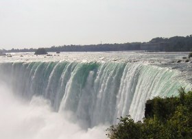
PROSPECT POINT, at the very brink of the ledge, offers a magnificent view of the American Falls, about 1,000 feet wide, the Canadian Falls, with its curved crest of about 2,500 feet, and Goat Island, which separates the two cataracts. The 'Thunderer of Waters,' as the Indian name for the Falls is translated, pours 205,000 cubic feet of water a second over the ledge and plunges with an energy of about 4,000,000 horsepower. Six per cent of the flow passes over the American Falls, the remaining 94 per cent over the Canadian Falls. The white, broken waters of the American Falls seem to hesitate momentarily, then roar over the brink and hit the rocks 157 feet below with a reverberating crash. The Canadian Falls, because of their distance, seem to descend in a smooth, noiseless sheet of water that gently bursts into an immense mass of surf and spray in the cauldron below. Both falls are tinted by rainbows and surmounted by mists that rise in pillars, then separate into lacy, floating clouds. In the evening, colored floodlights are trained on the falling waters. In the winter the freezing spray builds mountains of ice on both sides. Thrill-seekers walked from shore to shore over the ice bridge until tragedy befell a man and his wife in February 1912, when the ice bridge broke apart.
Daredevil stunts have been numerous. In 1829 Sam Patch leaped twice from a platform about 100 feet high into the gorge at the foot of the falls. In 1859 and 1860 Blondin, French tightrope walker, crossed and recrossed on a rope several times, once with his manager riding on his back. In the eighties several people navigated the rapids in barrels; in August 1886, William J. Kendall, a Boston policeman, passed through the rapids protected only by a cork life-preserver; in September 1889, Steve Brodie went over the falls in an India-rubber suit heavily padded and protected by steel bands. The first woman to go over in a barrel was Mrs. Annie Edson Taylor, a schoolteacher, in October 1901. Bobby Leach, an Englishman, went over Horseshoe Falls in a steel barrel in July 1911, and then spent 23 weeks in the hospital recuperating. Jean Laussier shot over the Falls in July 1928, and came out smiling, thanks to a rubber ball of his own construction. Several publicity seekers have lost their lives.
At the close of the Ice Age, the Niagara River plunged over the truncated edge of a dolomite formation into Lake Ontario. At the foot of the fall, the swirling water in time eroded the soft shales from under this massive rock. Blocks of the dolomite, thus undermined, broke off and caused a recession of the crest of the waterfall. As the fall receded, it formed the gorge. This action is still going on; it is estimated that the fall has moved southward from the southern shore of Lake Ontario to its present position at the rate of about one foot a year. If the fall reaches Lake Erie it will disappear. Steps are being proposed to arrest the process and to hold the fall to its present location.
At the Prospect Point parking area, elevators lead to the foot of the falls, close enough to the plunging water for one to become soaked with spray and mist and deafened by the roar of Niagara. A small steamer named Maid of the Mist bobs on the rushing currents and pierces the billowing spray beneath the cataract.
HENNEPIN POINT is said to be the spot on which Father Hennepin stood when he beheld the Falls and drew the first known picture of Niagara. There is a safe view down the precipice of 187 feet.
GOAT ISLAND, a 70-acre park banked by jagged perpendicular rock, splits the rapids into two cataracts and offers one of the best views of the Upper Rapids. The name is in reference to the bearded goat that was the only one of the herd to survive the winter of 1779, after having been left here by John Stedman. More than 200 rare plants grow here.
LUNA ISLAND affords a view of the brilliant rainbows that arch through the spray, even in the moonlight. In winter the island is transformed into a kingdom of ice.
The CAVE OF THE WINDS, reached by two elevators leading to the foot of the American Falls, is alive with stinging spray and buffeting blasts of air. A series of paths and bridges offers a succession of unusual views. The climax is the walk to the Rock of Ages, where Luna Fall crashes.
TERRAPIN POINT is connected with TERRAPIN ROCKS by handrailed walk. From the rocks is a view into the deep cleft that forms the apex of Horseshoe Falls, where the vast accumulation of water concentrates in a spectacular exhibition of power.
The THREE SISTER ISLANDS, named for the three daughters of General Parkhurst Whitney, builder of the Cataract House, provide splendid views of the Upper Rapids.
The NIAGARA FALLS MUSEUM, Riverway opposite Prospect Park, is a four-story stone building with a cupola. Founded in 1830 in Queen Victoria Park, Ontario, and moved here in 1864, the museum is one of the oldest in the country. The 700,000 exhibits include a tree 25 feet in diameter, the skeleton of a humpback whale, Indian relics, Eygptian mummies, the rubber ball of Laussier, the barrels in which Mrs. Annie Edson Taylor and Bobby Leach went over the falls, and the one in which Miss Martha Wagenfuhrer plunged through the whirlpool rapids.
The SHREDDED WHEAT PLANT, 424 Buffalo Ave., occupies two city blocks and employs 600 persons. Visitors are shown the processes in the manufacture of the company's products and are served luncheon.
The NIAGARA FALLS POWER PLANT, lower end of Canal Basin at the terminus of the hydraulic canal, contains three 70,000 horsepower units, among the largest hydroelectric generators ever constructed. Dating back to 1890, it marks the first and greatest development of hydroelectric power in the world. During the World War the company absorbed the earlier Niagara hydraulic developments.
WHIRLPOOL STATE PARK, Niagara Rapids Blvd. near College Ave., part of the New York State Niagara Reservation, provides splendid views of the swirling waters of the pothole whirlpool, 1,754 feet wide and 126 feet deep. Here the course of the river bends westward, and then, blocked by the jagged mouth of a filled glacial channel, curves back to follow the present gorge to Lake Ontario. Charles Dudley Warner wrote: 'When it [the Niagara River] reaches the whirlpool it is like a hungry animal returning and licking the shores for the prey it has missed.' The whirlpool has its gruesome side, for here Niagara usually gives up its dead; one old riverman has recovered 150 bodies.
WHIRLPOOL RAPIDS BRIDGE, built in 1887, a double-deck steel arch structure crossing to Niagara Falls, Ontario, provides an impressive view of the gorge and upper rapids.
|
|

This website is created and designed by Atlantis International, 2006
This is an unofficial website with educational purpose. All pictures, and trademarks are the property of their respective owners and may not be reproduced for any reason whatsoever. If proper notation of owned material is not given please notify us so we can make adjustments. No copyright infringement is intended.